

MaRisk
MaRisk
MaRisk is the core module within the Risk Intelligence System, specifically tailored for maritime clients, providing valid, actionable intelligence to any fleet 24/7.
It serves as a benchmark platform for maritime intelligence since 2008 and has undergone continuous development, with the latest unveiling being its 4th generation. MaRisk seamlessly integrates fleet tracking and navigation systems with advanced risk intelligence, offering a comprehensive suite of features to clients in a single view.
With MaRisk, clients can efficiently manage fleets and navigate risks, equipped with actionable insights accessible from any device, 24/7. Furthermore, MaRisk subscribers enjoy the added benefit of accessing the Duty Watch Team, ensuring immediate support during critical situations. This combination of advanced technology and expert support empowers clients to make informed decisions and safeguard their operations effectively.

MaRisk subscription
✓ A user-friendly and easy to navigate System
✓ 24/7 incident updates
✓ Access to Risk Intelligence Duty Watch team for queries
✓ Country and Area threat assessments
✓ Enhanced Areas Drawing Tool
✓ Recommendations and guidance
✓ Satellite fleet tracking integration as SAT AIS vessel position integration
✓ Global maps (including digital sea charts)
✓ Statistics tool
✓ Company documents sharing

Experience the system in the context of your operations:

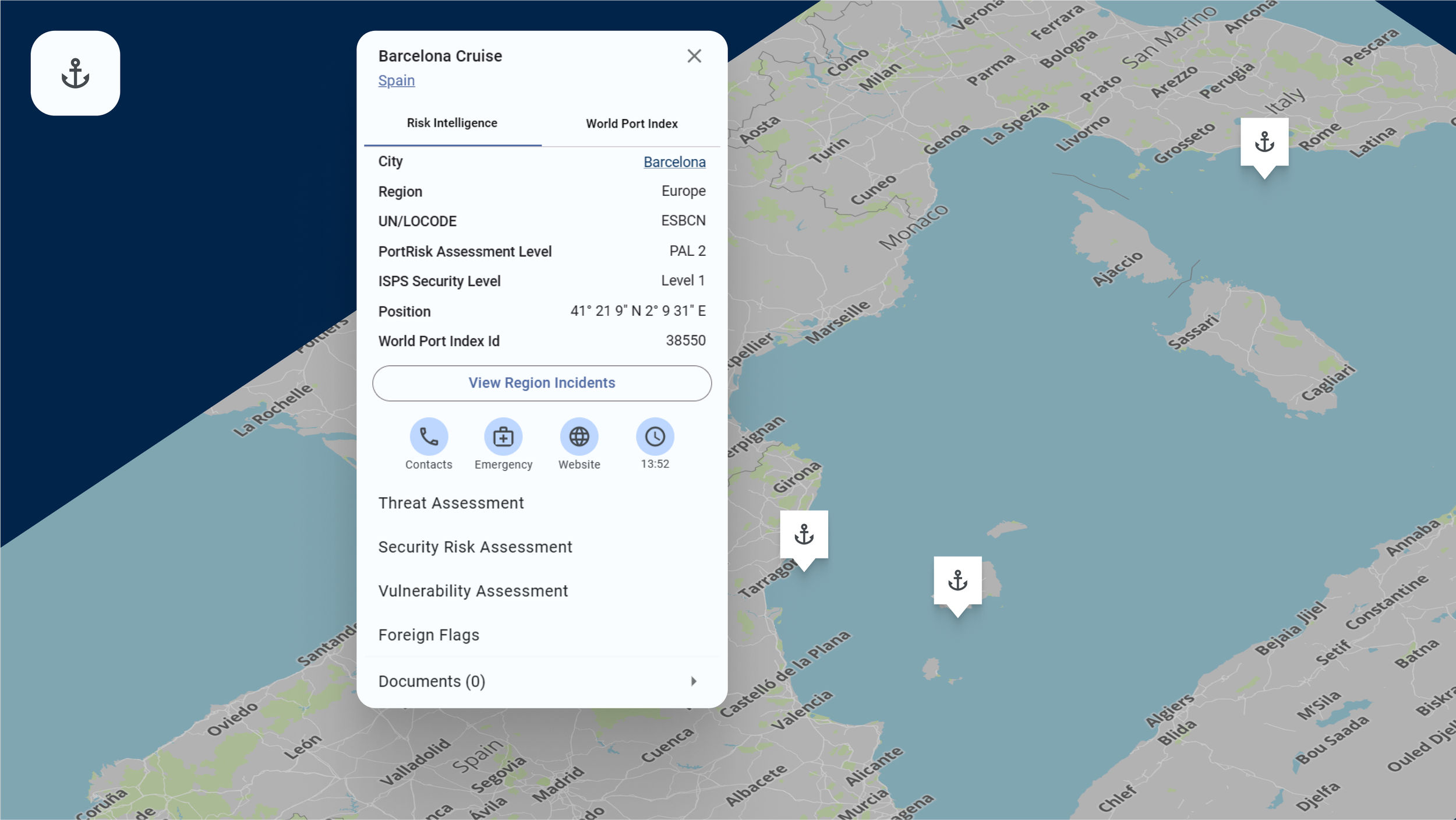
Ports
Experience the unparalleled advantage of Ports, the essential port security intelligence tool relied upon by maritime professionals worldwide. Delivering validated risk assessments and real-time incident alerts, Ports ensures users have critical information at their fingertips. It empowers Masters and Security Officers to make informed decisions when approaching various ports.
In-Depth Insights
Benefit from comprehensive port risk assessments, incident alerts, and threat assessments, empowering Masters and Security Officers to evaluate risk levels when approaching ports.
Expert Analysis
All data within Ports is meticulously sourced, analysed, and assessed by our team of experienced analysts, ensuring reliability and accuracy.
World Port Index
Whilst only high threat ports will carry the Risk Intelligence threat assessments, you can now use the System for keeping standard port call SOPs on your respective call destinations – even those in benign areas.
Cruise Terminals
Designed to improve the capabilities of cruise vessel operators, this feature provides flexibility and customisation options. Our unique approach combines on-site surveys, expert analysis, and advisory services, offering the best combination of detail and accuracy.
Enhanced Security Assessments
Collaboration with clients through Advisory Services ensures that vulnerability assessments are tailored to clients' specific needs, resulting in more accurate and comprehensive evaluations of potential risks.
Custom Documentation
Users can effortlessly attach their own documentation to any listed terminal on the system.
Crew Training and Checklists
Organisations can keep crews well-prepared with our training resources and checklists, ensuring their readiness for any situation.
Voyage Intelligence Tool

Upload your voyage waypoints to monitor your planned route in real-time. Receive risk alerts, threat assessments, and live vessel tracking from a single view. Customise alerts to receive timely notifications of incidents or heightened threats along your route. Evaluate security risks to minimise potential dangers and optimise decision-making.
Proprietary Risk Intelligence Database
Access our proprietary database for thorough threat assessments, leveraging historical incident data to plan new voyages in unfamiliar areas confidently.
Tailored Alerts
Customise and save your routes to receive alerts specific to your voyage, ensuring proactive risk management.
Effortless Route Planning
Easily upload waypoints and receive automated warnings for any incidents or heightened threats along your route.
AIS Tracking

Easily locate any vessel equipped with Automatic Identification System (AIS) using its IMO or MMSI. Gain invaluable insights into vessel movements, including track history, ports of call, and identification of AIS gaps.
Analyse AIS Gaps
Utilise our Gap Analysis tool within the Risk Intelligence System to identify potential gaps in AIS transmissions, flagging areas of interest for further investigation.
Identify Ports of Call:
Explore the destinations visited by the vessel, providing valuable context for operational and strategic decision-making. Leverage our machine learning feature to predict likely ports of call or Ship-to-Ship (STS) transfer areas, enhancing proactive risk management efforts
Advisory Services:
For those who wish to dive deeper, our Advisory Services and analysis team can work with you and our partners at Geollect to layer radio frequency, synthetic aperture radar and satellite imagery to provide concrete evidence alongside our best-in-class analysis to support legal cases and disputes.
Track Vessel Movements
Follow the precise path of any AIS-equipped vessel, allowing you to monitor its journey in real-time or review past routes.
Sanctions

Stay ahead of regulatory requirements and mitigate potential risks with our Sanctions feature, which provides continuous monitoring of Office of Foreign Assets Control (OFAC), European Union (EU), and United Kingdom (UK) Sanctions. This feature ensures you are promptly updated with the latest sanctions information, enabling quick identification of potential risks or compliance issues.
Compliance Support
Access comprehensive transactional KYCC services through our direct connection with partners at Macura, facilitating streamlined compliance processes and mitigating risks associated with sanctions violations.
Automated Alerts
Receive automated alerts regarding any new sanctions or updates, ensuring timely compliance and risk mitigation.
My Fleet

Monitor your vessel positions effortlessly with the Risk Intelligence System's advanced tracking capabilities. Visualise up to 4000 vessels simultaneously, providing you with comprehensive situational awareness of maritime traffic in your vicinity.
Alerts and Notifications
Set custom alerts for specific vessels, allowing you to be the first to know if any incidents occur within a pre-defined radius of your vessel. Receive instant notifications to take timely action and mitigate potential risks effectively.
Customisable Visualisation
Tailor the visualisation of vessel positions to suit your preferences and operational requirements. Filter vessels based on criteria such as vessel type, destination, or proximity to sensitive areas, ensuring focused monitoring and efficient decision-making.
Real-Time Tracking
Access live updates of vessel positions, enabling you to monitor vessel movements with precision and accuracy.
Alerts

Enhance your ability to stay informed and proactive. You have the option to define personalised alerts, enabling them to closely monitor incidents and changes in threats within designated threat areas or ports from the Risk Intelligence System.
Vessel-Specific Alerts
Set alerts for specific vessels within your fleet or others interest to them. This functionality ensures promptly notifications of any significant developments involving vessels, facilitating proactive risk management and response.
User-Defined Areas of Interest
Draw and designate own areas of interest on the map, empowering real-time alerts regarding any incidents occurring within these specified regions. Enhances situational awareness and enable monitoring critical areas relevant to your operations.
Customisable Alerts
Define personalised alert criteria, tailoring notifications to specific operational needs. Monitor incidents and changes in threats within designated areas, ports, countries, or threat areas, ensuring relevant and timely updates.
Enhanced Drawing Tool

Harness this feature’s power to create intricate shapes and tailor attributes for personalised monitoring. Establish geo-fences to ensure precise risk management and comprehensive surveillance across your operations.
Enable Geo-Fencing
Designate boundaries and establish virtual perimeters around your drawn areas. Activate notifications or alerts to trigger when vessels or incidents enter or exit the defined boundaries. Enhance real-time monitoring and situational awareness.
Access Precision Drawing
Create precise and detailed shapes on the map within the Risk Intelligence System. Ensure accuracy in defining specific geographic areas by utilising this feature.

Get an unlimited free trial now
Empower your operations with the latest advancements in risk intelligence. Discover how our platform can revolutionise your approach to maritime security and decision-making.
Request a live demo today and discover the unique features that set us apart. Our qualified maritime risk analysts will guide you through a personalised demonstration tailored to address your specific needs. This will help you understand how the system can benefit your organisation.
I have been using MaRisk from from Risk Intelligence since 2010
— Captain Daniel Musafia, Company Security Officer, Columbia Shipmanagement
“MaRisk an essential tool - not only to increase the CSO's knowledge and awareness, but to transmit that knowledge and awareness to a ship's crew to keep them on alert when and where required.”
SIGN UP FOR A FREE TRIAL:
Risk Intelligence A/S
Strandvejen 100
2900 Hellerup
Denmark
T: +45 70 26 62 30
F: +45 70 26 62 40
Email: info@riskintelligence.eu